
Sunday, December 27, 2009
Wednesday, December 23, 2009


Friday, November 20, 2009

Sunday, November 15, 2009
New Eva Galson Orchid Calendar for 2010
 New Eva Galson Orchid Calendar for 2010 is now available on my RedBubble site. This calendar celebrates Eva's passion for cultivating and photographing these amazing plants. Images are available as individual greeting cards, or as matted wall art as well. Click here to view details of each page.
Thursday, November 12, 2009

Monday, November 9, 2009
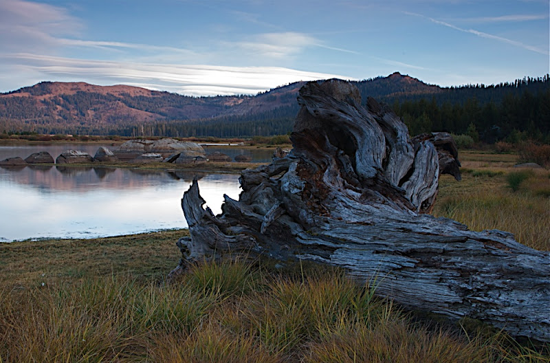
Nov. 2009 - Pyramid Lake, NV
(click on center of image to view slide show...)
We stare blankly at each other as our worst fears are realized. We're miles from anywhere, on a spur road off an unimproved dirt road, at the edge of an abandoned lake the size of Lake Tahoe and the camper appears to be stuck in the soft mineral sand that we both mistook for a passable roadway. No need to spin the tires. Its evident from the motion of the vehicle and the effort of the engine that this dog just won't hunt. I turn off the engine and we both get out to inspect the damage and to brainstorm a solution. Already, my mind is racing ahead to scenarios - how far we'll need to hike before we can flag down some fisherman's truck that can take us miles down the dirt track to a pay phone where we can try to call a tow truck that is far away to begin with and suitably rugged to not get stuck themselves while winching us out of our mired condition. I think about our self contained bag of tricks. Diane starts rifling through the bench compartments for our folding shovel, but I know digging won't solve the problem. We're already well dug in. Whose idea was it anyway to venture this far afield at this crazy hour in hopes of getting a photo of the amazing sunset colors on a far off set of rocks perched at the remote end of the lake - oh yeah... mine.
Then it hits me - thinking of those desert island airstrips built in the far flung pacific islands - I need some sort of grating to put under the wheels, and then we can slowing roll onto it and piece by piece work our way back to solid dirt. Diane catches onto the idea quickly and stops looking for the shovel, now considering the various pieces of carpeting we have scattered near the seats at our feet. I dig into the "garage" our back door's storage compartment and pull out 10 pieces of plastic lego block we use to level the car on uneven campsites. I sink a few behind each wheel after pushing the powdery sand away from the mud flaps with my arms, jump back into the cockpit, and slowly backup. Perfect. The truck climbs happily onto solid footing - as if it too, was nervous about the floating that was happening in the powdery mineral pit. Now, I lined up a few in front of the rear wheels, and rolled forward 8 inches. Everything held. We were moving albeit slowly forward. So, that's how we crawled out of that dead end spur - Diane outside in the sage and sand slowly advancing the plastic lego panels in front of the wheels as I drove painstakingly forward. We'd drive onto a set, and then Diane would take the previous foothold and move it in front of the wheels for another 8" of forward motion. In no time, we were free and full of giggles, the smelly nervous sweat already evaporating from our clothes.
For the balance of our journey on this Paiute Indian reservation, Diane led out in front by foot when we got to questionable sections, scraping her feet on the ground to see if it puffed away in a powdery wisps, or if it held firm. Go girl!!
Tuesday, November 3, 2009
New 2010 Photo Calendars for sale

 New Calendars for sale
Click here to preview Landscape Calendar
Click here to preview Flower/Plant Calendar
Greeting cards can be selected in any quantity from a singe or multiple sets of images.

Monday, November 2, 2009
Lake Van Norden - more sunsets
 |
| From Lake Van Norden, Judah moonrise |
 |
| From Lake Van Norden, Judah moonrise |
Hiking at sunset near Lake Van Norden. First photo is the moon rising at sunset, and the second is of Mt. Judah and Mt. Disney across Lake Van Norden.
Sunday, October 25, 2009
Lost Trail Lodge
This time, we took the bikes to make better time and went exploring to find the Lost Trail Lodge. (Actually - if we had bothered to look at their web site, they publish very clear instructions for how to get there) - The lodge is actually easy to find if you know where to look - just 2.9 miles in Coldstream road - a forest service road that leaves right from behind the Holiday Inn in Truckee. The owner and lodge host, Dave, met us as we peddled up and offered us a cup of tea or coffee and proceeded to entertain us for 30 minutes with stories of great times at the lodge. This cozy, fully winterized and comfortable lodge is totally off the grid, with a well, and running water (read flush toilets) and sits surrounded by forest service land, within striking distance of some very exiting skiing and ski touring. The lodge is stuffed with knick-knacks of every sort - but of special note is a large collection of musical instruments - all in working order and available to guests to play if they know how. Dave is himself an accomplished musician and enjoys hosting musically themed events. We can't wait to return when snow is on the ground. Don't know why it took us so long to hook into this convenient and remarkable facility.
Saturday, October 24, 2009
Crow's Nest Ridge Hike - October 2009
Hike from Pahatsi Rd. to Crow's Nest. Temperatures in the 60's, very calm air. Many signs of bobcat along the trail, but no sightings.
( Click on center of picture to view slide show... )
( Click on center of picture to view slide show... )
Monday, October 12, 2009
Mid October - Donner Summit
Last weekend brought our first house guests of the season (Don/Margaret and Maya/Mike). We worked out the kinks of sharing this house with others and made some great meals. The bird food on the deck continues to attract large flocks of stellar jays - all squabbling over the food like a bunch of gulls. The woodpeckers stick to the trees and the other smaller birds avoid the congestion on the deck. The night temperatures bring morning low-lying fog to Van Norden meadow, but the sun has been burning it off for pleasant conditions for fall hikes.
This weekend was the Sugarbowl National Ski Patrol refresher. Winter friendships from last season were rekindled, rivalries reestablished, and lots of good training occurred with a steady rotation through first aid scenario stations. Lift evacuation drills, avalanche rescue drills, and a general welcoming back to the Sugarbowl community.
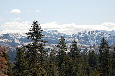
Last week's season's first snowfal left 4-6 inches on the ground at the higher elevations. In the distance here is the Sugarbowl ski resort skot from Castle Pass on the north side of Rt. 80
Early morning fog on Van Norden meadow.
Castle Peak - from Castle Pass
This weekend was the Sugarbowl National Ski Patrol refresher. Winter friendships from last season were rekindled, rivalries reestablished, and lots of good training occurred with a steady rotation through first aid scenario stations. Lift evacuation drills, avalanche rescue drills, and a general welcoming back to the Sugarbowl community.
 |
| From Oct Donner Summit 2009 |
Last week's season's first snowfal left 4-6 inches on the ground at the higher elevations. In the distance here is the Sugarbowl ski resort skot from Castle Pass on the north side of Rt. 80
 |
| From Oct Donner Summit 2009 |
Early morning fog on Van Norden meadow.
 |
| From Oct Donner Summit 2009 |
Castle Peak - from Castle Pass
 |
| From Oct Donner Summit 2009 |
 |
| From Oct Donner Summit 2009 |
 |
| From Oct Donner Summit 2009 |
Sunday, October 4, 2009
09_October Desolation Wilderness - Summer turns to Fall
Thinking we'd get some great fall hiking in we ventured down to the southwest corner of Lake Tahoe and spent a few days exploring various trails that penetrate into the Desolation Wilderness. Eagle Lake, Grass Lake, Fallen Leaf Lake, Cascade Lake and more. Along the way we encountered the historically preserved Glen Alpine Springs Resort complete with it's own Soda Springs and Maybeck designed "fireproof" buildings a mile west and in from the end of Fallen Leaf Lake. We stopped briefly to chat with the owner and chief preserver and learned some interesting history about this area. On Saturday night, a heavy rain turned to snow and in the morning we had 3 inches of fresh snow to contend with. The shuttling clouds made a great backdrop for Emerald Bay.
(Click on the "play" button in the center of the image below to start slide show..)
(Click on the "play" button in the center of the image below to start slide show..)
Monday, September 28, 2009
We do not inherit this land...
"We do not inherit this land from our ancestors; we borrow it from our children."
-Haida Indian saying
-Haida Indian saying
Saturday, September 26, 2009
Lake Van Norden and Upper Lola Montez Lake
Still exploring around the house, we are very pleased with what we discover. The hike in to Upper Lola Montez Lake early this morning - following the fabled Hole in the Ground trail - backwards - was peaceful and enjoyable. As the day wore on, however, the temperature continued to rise. By the time I reached the Upper Lola Montez Lake (via a scramble from the lower Lola Montez Lake) the temperatures had topped out over 85. We rested in the shade for an hour and rambled back down the mountain in the dusty aftermath of a handful of sweaty mountain bikers at the tail end of their grueling ride down from Castle Creek.
Sunday, September 20, 2009
18 September - Lake Tahoe, Little Lakes Valley, Upper Sardine Lake
(Float over photo and click to see slide show...)
We sneak away from Donner summit to seek out fall colors and some solitude on the eastern side of the Sierras. Passing Lake Tahoe on the way we were glad to leave the early fall crowds well behind. We made several excellent day hikes to reliably dramatic mountain canyons south of Mono Lake. First stop - Tom's Place and Little Lakes Valley. Sparkling aspens, dark blue skies, and cold clear mountain streams and lakes dot this gently sloping canyon as it rises to the Sierra Crest. Next day we explore the north end of The June Lake loop and discover a remarkable mountain railway - still in use to service the dam 2,000 feet above the valley floor, passing Gem and Agnew lake. Third day we camped at the Walker Lake trail head and ventured up and up and up to Upper Sardine Lake, passing Bloody Mountain - with incredible vistas back to the Mono Lake Basin. This hike passes through what I imagine is as close to virgin Sierra forest as possible, with gigantic Doug Fir, and Juniper trees - some with over 7' trunks. No sign of previous logging was evident, and the mature alpine forests were a treat to experience.
Monday, September 14, 2009
14 September - Lake Van Norden at dusk
(Float over picture and click to view slide show...)
The day's work done, I venture out at dusk to immerse myself in the quiet and the magic of the daily transition from daytime to night. There is a stirring in the underbrush as quail, and rabbit and other small rodents come out of their daytime cover and begin to forage. As I pad silently through the soft grass at the water's edge I can see them all as they peer back. The geese out on a rock island stir uneasily as they sense my presence - and in turn the birds rise in batches to check out the newcomer. The sky turns from blue to orange to gray to black and a light mist rises from the warm lake surface. The water's unrippled mirror reflects the first planets to light the sky and I realize too late I have not brought a flashlight, and I've lingered too long in the dusk trying to blend in and be accepted. I pack my things, bend my stiff knees and feel my way back towards home, through the high willows, over the silent dam overflow and back to the road. I wish I could convey the cool mountain air's brush on my cheek and the nightime sounds when the photos are displayed.
Sunday, September 13, 2009
Sept. 13 - Loch Leven Hike with Jeff and Karen (lower, middle, high)
(Float over photo and click to see slide show...)
We must have picked the hottest day all summer to make this 7 mile round trip hike to the Loch Leven basin south of Rainbow Lodge. Luckily, the cool alpine lake water was a welcome and well deserved treat after the climb up to the lakes. When we returned to the car the thermometer was in the 90's.
Sunday, September 6, 2009
August 2009 - Pumpkin Island, 1000 Islands, St. Lawrence River, Ontario
(Float over photo and click to see slide show...)
Diane and I had the pleasure of spending almost two weeks on Pumpkin Island, amidst the 1,000 Island archipelago of the St. Lawrence River separating Canada from the United States just north of New York State. Lazy days were spent relaxing, swimming, kayaking, bird watching, sailing, preparing, and eating amazing meals with a changing constellation of David's family. The moon was rising close to full while wer were there, and with clear nights we had some amazing moonlit nights on the water. Every afternoon the wind seemed to perk up so there were plenty of romps up and down the river in the Shark named "Nirelle".
Thursday, August 13, 2009
Farm visit - western New York
Visit to Candice and Doug's hay and corn farm in western New York
Float over image and click play button to view all the photos
Wednesday, June 17, 2009
Drive up the CA Coast
Visit to Candice and Doug's hay and corn farm in western New York
Float over image and click play button to view all the photosAfter attending Ross's graduation at Cal Poly, we took a trip to wander about the central coast before returning home. We had an astounding trip, but can already tell the summer hoards are out of school and filing up the afternoon roadways and up until now, empty campgrounds. Some highlights of the trip include:
- Watching grey whales breach and frolic just offshore near Rockland
- Amazing hamburgers and stories at the family run burger stand at Jalama Beach - just below Point Conception at the inflection point of California's coast
- Amazing sublime sunsets lasting until after 9 pm
- wildflowers and blooming Jucca plants
- reading native american california history while traveling through the territory
- big sky views and pounding surf to fall asleep by
Wednesday, June 3, 2009
Quick trip south along the edge of Olympic National Park
 |
| From Olympic Pennisula |
 |
| From Olympic Pennisula |
 |
| From Olympic Pennisula |
Tuesday, May 26, 2009
26-29 May 2009 | Vancouver
 |
| From Vancouver |
Barred Owl - Pacific Spirit Regional Park, Vancouver. This guy was perched at the edge of a big forest, staring down intensely into the ferns and bushes by the edge of the meadow. He hardly cared that we were there, much less taking his picture. He looked about for awhile, and seeing that our presence was disturbing the mice between us both, he flew off a short distance for better hunting.
 |
| From Vancouver |
Fiddlehead Fern - Pacific Spirit Regional Park, Vancouver
We have been marooned in Vancouver. An electrical failure in the camper has disabled the entire ignition system as well as the electronic keys. Parts have been special ordered (from Texas), but the Mercedes-Benz supply chain is narrow and specialized for these electronic modules, so we are at the mercy of someone's computerized supply chain system and cannot seem to influence anyone to rush more than the system allows - even though our friendly airstream rep. has chipped in to try and pull strings. So, we pack small bags, grab some groceries from the fridge, tow the camper to a dealer across town, and abandon Harvey there to fend for himself. We have booked a room in a residential hotel overlooking Vancouver's west end and we are amusing ourselves here in Vancouver by foot and bike until our ship is operational again. Word is anywhere from 3 days to 2 weeks.
 |
| From Vancouver 2 |
 |
| From Vancouver 2 |
First Nations Totem Pole - Stanley Park
 |
| From Vancouver 2 |
Sea Stack from Seawall bike path looking west
 |
| From Vancouver 2 |
 |
| From Vancouver 2 |

Cast aluminum sculpture - 1/2 size waterfront wharehouse building on piers - amazing detail.

 |
| From Vancouver 2 |
Friday, May 22, 2009
22May2009 | North Cascades
 |
| From North Cascades |
 |
| From North Cascades |
 |
| From North Cascades |
 |
| From North Cascades |
 |
| From North Cascades |
 |
| From North Cascades |
 |
| From North Cascades |
 |
| From North Cascades |
 |
| From North Cascades |
 |
| From North Cascades |
 |
| From North Cascades |
 |
| From North Cascades |
 |
| From North Cascades |
 |
| From North Cascades |
Tuesday, May 19, 2009
Old Maori saying...Turn towards the sun...
Old Maori saying:
"Turn towards the sun and all your shadows will fall behind you."
"Turn towards the sun and all your shadows will fall behind you."
Monday, May 18, 2009
We shall not cease from exploration - T.S. Elliot Quote
We shall not cease from exploration
And the end of all our exploring
Will be to arrive where we started
And know the place for the first time.
–T.S. Elliot
And the end of all our exploring
Will be to arrive where we started
And know the place for the first time.
–T.S. Elliot
Wednesday, May 13, 2009
May 11 2009 - Virginia Lakes Spring Skiing
Slide Show:
You can click into the map and drag the mouse around to view surrounding terrain.
View Larger Map
You can click into the map and drag the mouse around to view surrounding terrain.
View Larger Map
Saturday, May 9, 2009
May 9, 2009 – Cairns – A Timeless Syntax
Piled stones, balanced a few high, made of all natural and locally available materials, assembled with no special tools besides a basic intuitive and empirical understanding of balancing objects, stones held together by gravity and their unique interlocking and granular surfaces, arranged in a way just different enough from the natural order of things that they stand out to the human cognition system and communicate a clear message – this way forward and that way back.
The syntax of this message has remained unchanged since our ancestors ventured out of the trees and began to explore the great savanna. The simplicity and elegance of this human gesture, to pass information from one human to another, whom may be separated by time, community, affiliation, language, and geo-political perspective. Most other long standing forms of cross dimensional communication require complex keys or technology to create, decode, perceive and understand. But the cairn is one of the purest, self defining autonomous objects the human species has ever devised.
One can exist alone with a certain symmetrical power but limited impact. There is even a current resurgence in the building of stand-alone cairns. If you visit a river bed or beach with polished stones where other people have been recently it is not surprising to find these precariously, but artistically stacked stones. They attest to the patience and special prowess of the assembler but beyond their fundamental artistry and isolated beauty they have little more to say to the observer. The real art in my opinion, is in the process and vision required to assemble these stackings.
But, when one isolated cairn is considered with a community of other cairns - essentially networked, they become very powerful as a persistent communication system. Follow these stackings from one to another and you will be led to a new place predictably. Follow them in reverse order and you will be able to return from whence you came. In an uncertain world, with confusing and sometimes unrecognizable landmarks, such networks of cairns offer a calming relief.
Another beauty of the cairn system, is that there is no need to see in advance or in retreat more than a single cairn. It supports the NOW. They allow the traveler to experience what is here and available immediately without the need to anticipate the future or to remember the past. There is not the need for an overview, and the message delivered is not an abstraction of the way – it IS the way. Other forms of maps require the map reader to be several levels of abstraction away from the reality of their actual experience in order to make use of the device. Consider a trail map – it is first off – two dimensional, not three, and that limitation alone assumes a basic cognition and abstraction skill. Then, it is not really represented by points, but by lines –a path that leads from here to there. Immediately upon viewing and comprehending the user sees what is ahead for quite a ways. Now, granted, for certain kinds of travel over certain types of terrain this is indeed essential in order to properly prepare for the journey. However, when considering a simple single day’s outing over basically navigable terrain, the map can rob one of the true exploratory experience. Under these circumstances, I much prefer the NOW of the cairn and the connection it gives me to the long traditions of my nomadic tribe.
 |
| From 12 May 2009 - Southern Utah |
 |
| From 12 May 2009 - Southern Utah |
 |
| From 12 May 2009 - Southern Utah |
Friday, May 8, 2009
May 8, 2009 - Dry Gulch Slot Canyons GSENM
Another 15 miles down a washboard dirt and clay road through open range land left our filings jarred and a fine layer of brown silt over much of the interior of the cabin – dust must be blowing in through the rubber porthole gaskets or other vent openings. Off to our right the Kaparowits Plateau grew taller and more awe inspiring as it dominated the views on that entire side of the road. The running boards each held shovels of fine red dirt, and the wheels had turned brown. The camper swayed to and fro as if a child were playing with us in a giant sandbox as we bounced slowly over the uneven roadbed and negotiated the larger rocks and ruts in the road. It felt like we were at times driving across the diameter of a giant sand record, with groves placed just so to harmonize with the springs in our vehicle to set everything bouncing. We slowed to a crawl, and hugged the side of the road in hopes that the soft sand under one set of wheels would help dampen the beating the other set of wheels were taking. At one point a low wash was filled with deep white powdery mineral (like borax, or gypsum) that previous drivers had left parted and rutted like a snow covered road right after a storm. We waded in and immediately felt the sway and drift of the wheels as if they were catching somewhat, but floating somewhat. Keeping the wheels turning, and our momentum moving forward we sloshed through this sand pit without getting wallowed down or stuck.
At last, we came to an unmarked spur off to the left and crossed our fingers that the odometer reading and the advice we were given were both sufficiently accurate to guide us to a trail head instead of some backcountry dead end – or worse some narrow rutted roadbed with soft sandy shoulders from which we would have difficulty backtracking, much less turning around. Almost immediately we came to another fork in the road – both options equally unused. No one had mentioned the second fork. We discussed our impressions, turned the wheel left and launched ahead. Luckily after about 5 minutes we arrived at an isolated opening in the sand and scrub where it was obvious others had parked.
A loosely marked trail led us down over the slickrock to a dry wash several hundred feet below, where other written reports had indicated to us that a collection of slot canyons terminated. Peck-a-boo slot, spooky slot, and dry wash slot all had names on written descriptions, but with no trail markers – or even a well worn trail we needed to follow our noses to find the often hidden openings of these magical routes.
The first slot we selected was called Peek-a-boo Canyon and involved climbing up from the wash about 12 feet over a dry sculpted sandstone overflow where a few footholds had been carved to assist with the entry. Well, try looking up 12 feet, and imagine climbing up near vertical sandstone, smoothed by fast rushing water for a millennium, with no cracks or deformities, using only rounded footholds and no handholds into an unknown and invisible ledge where more gymnastics undoubtedly awaited. I boosted Diane on my thigh, and then followed her up. After reaching the first pour over however, Diane decided she was not going to be able to get down the following pitch, so we retraced our delicate maneuvers and regrouped on the sandy dry pool where we started. I decided I was going to go in and have a look around anyway and climbed back in. While I was setting up the camera for a few shots another intrepid adventurer walked up and told us once through the canyon, we could climb out and hike back to the start over the top. Diane took up a seat in the shade and I ventured forth to explore the unknown vowing to meet up again within an hour.
What I experienced inside this amazing grotto was a quiet, softly lit cathedral of undulating sandstone curves with a sandy pocketed river bed. I climbed over and around finely crafted dry pools, spill overs, and long ago evaporated whirlpool “keeper” holes. The walls overhead sometimes overhung, often sloped in parallel directions, but not vertical, always one tilt or another. The walls were etched with grooves from eons of water and mud rushing down as it accumulated from the mesa overhead, swirling around laden with sand, and stones, and boulders, and tree limbs. All that debris is now gone, and all that remains is the lithographed sandstone telling the tale.
With the walls relatively close together I could usually “jamb” across the narrow cavities to climb up and over the geologic obstacles. Other times I had to “smear” up the smooth surfaces, hoping that just about the time my friction wore out I would be able to reach a sharp enough handhold that I could reset my feet. It was not desperate, but I was alone, and I did not want to abandon Diane for too long.
The next slot we tackled was called “Spooky” slot and it was indeed a bit spooky. This canyon had an easier entrance, but was longer than the previous slot, and rapidly became so narrow that we could only pass sidestepping, with our packs off and held to one side. A few steps like this would have been interesting, but traveling this way for 1/3 of a mile was exhausting. Again, the walls undulated back and forth, in a sinuous fashion, and the warm light filtered down to where we were squeezing without any direct rays getting anywhere near the bottom. Like in a cave, with an open top the air flowed regularly down as if it were water, a mild 60 degrees - cool, but well suited to our level of exertion. Occasionally we came to a swirled out open pocket, where the eddies of water had carved out a spherical or circular pool 4 feet wide. We took these opportunities to rest, drink, eat snacks, and marvel at our surroundings. Often the closely spaced walls were not vertical at all, and we would need to lean over, front or back continuing our awkward sidestepping. Even with this close spacing of the massive rock cliffs front and back, I never really felt claustrophobic. With the fresh breeze blowing, and the warm glow of the light, we would just stop and rest and marvel at the situation we had put ourselves in. Bigger people would definitely feel more constrained. Finally, the slot became so narrow and small we could no longer make forward progress. To boot, overhead falling rocks had filled in the open top making a jumble of chock stones into a 3D vertical maze. Luckily, just overhead, the slot widened a bit – this is of course why the chock stones had gotten stuck in their tumble down the canyon. The way up must be our exit route. We climbed straight up, the growing chimney, moving around one rock, then over and up and around the next, until after a few minutes of exhilarating climbing we emerged into the polar white sun-blasted desert – looking down and back it was hard to imagine there was even room down beneath the jumble of rocks for someone to pass, but as we heard voices, grunts and giggles waft up from the tumble, we were assured that indeed there were people down there, and they, like us, were on their way up to percolate to the surface just as we had. It is not hard to imagine, how one, not informed about this grotto pathway below, would experience the appearance of a human from such terrain as magical.
We found ourselves in a non-descript sandy wash (that drained in wetter seasons through the slot). Searching for a logical way back to our start point without having to reverse engineer our subterranean trip, and spied the remains of soft footprints in the sand and following our inner compass, and the fall of the land, we soon spotted the dry wash from which we had started our journey and merrily hiked back to the mouth.
 |
| From 12 May 2009 - Southern Utah |
 |
| From 12 May 2009 - Southern Utah |
 |
| From 12 May 2009 - Southern Utah |
Subscribe to:
Posts (Atom)