Friday, December 24, 2010
Wednesday, December 22, 2010
Wednesday, December 15, 2010
Sri Lanka Favorite Photos
Slide show embedded below. Float over the image and click on the play button.
More writings, poetry, and a group journal can be found at the Sri Lanka Group Blog
Friday, December 10, 2010
The Cinnamon Peeler - by Michael Ondaaje (who writes about Sri Lanka)
If I were a cinnamon peeler
I would ride your bed
and leave the yellow bark dust
on your pillow.
Your breasts and shoulders would reek
you could never walk through the markets
without the profession of my fingers
floating over you. The blind
would stumble certain of whom they approached
though you might bathe
under rain gutters, monsoon.
Here on the upper thigh
at the smooth pasture
neighbor to your hair
or the crease
that cuts your back. This ankle.
You will be known among strangers
as the cinnamon peeler's wife.
I could hardly glance at you
before marriage
never touch you
- your keen nosed mother, your rough brothers.
I buried my hands
in saffron, disguised them
over smoking tar,
helped the honey gatherers...
When we swam once
I touched you in the water
and our bodies remained free,
you could hold me and be blind of smell.
You climbed the bank and said
this is how you touch other women
and the grass cutter's wife, the lime burner's daughter.
And you searched your arms
for the missing perfume
and knew
what good is it
to be the lime burner's daughter
left with no trace
as if not spoken to in the act of love
as if wounded without the pleasure of a scar.
You touched
your belly to my hands
in the dry air and said
I am the cinnamon
peeler's wife. Smell me.
Thursday, December 9, 2010

Tuesday, December 7, 2010


Tea Country Explorations
Today, we took an early morning hike before a sumptuous breakfast,,,
Morning Hike:
==========
Floating in a rolling sea of tea plants, with distant train whistle sounding like a foghorn, we search in the swells for nature's clues. Bear Monkey jumps in the canopy above to get a view of the bipeds below before leaping away for another breakfast course in the treetops. Tracks of Sampa Deer, Mouse Deer and leavings of porcupine are clear in the muddy trail we follow. A tiny spider decends from far above on a single gosimer thread, holding tight to his parachute leaf, looking to cast a net for some smaller prey. Wild boars have routed in the soft earth, rearranging the forest floor in search of grubs and mushrooms.
Grey Tea factory walls merge with the grey sky while clouds weep, and ground seeps. Tamil women picking tea by hand - a work of endless toil, Tamil men weeding rows with well worn ageless hoes. Barefoot children laugh and chase us pushing, pulling, rolling a rubber hoop with a hooked stick - a game known round the world. One boy runs past, with small hand clasping a crumbled bill - on his way to the village market to pick up something from the store. We leave the village below and ascend the stone steps through the tea plants to return to our windy castle on the knoll, enshrouded in fog to be pampered with padded seats, and silver covered serving dishes, served delicacies and endless hot tea.
Thursday, December 2, 2010
Morning drizzle and bird song
Myriad of bird song greets the dawn and I can barely imagine the vast diversity of the animal community which surrounds us on our hillside perch overlooking Sigiriya's rock across the lake.
Monkey's whoop joins in and we must remember to latch our deck door to prevent the prying fingers of inquisitive primates from sharing in our luxury.
Wednesday, December 1, 2010
Sri Lanka kick-off
Today we mountain biked through the ruins of an ancient capital city stopping often to explore the carved stone Buddahs and other special religious sites. The are groups of wild lemurs about providing entertainment. Our progress is halting as we stop many times along the way to admire the birds.
Along the way we've seen wild elephants, monitor lizards, a gray mongoose, and a 4" Giant wood spider. Really glad I did not walk into that web unexpectantly.
The group has bonded well and we are all enjoying each others company. Our minibus has large windows and the driver stops often along the shoulder of the narrow roadways when we spy interesting distractions.
Hard to tap out more prosaic text on my iPhone but I am looking to more prodigious posts later.
Saturday, November 27, 2010
Dubai - one day stop over - Old City
Wednesday, November 24, 2010
Packing for the tropics on the coldest day of the year
Friday, November 19, 2010
Ski-In/ Ski Out Condo available for short term rental at Donner Ski Ranch - minutes from Sugarbowl and Royal Gorge
10150 Ski Ranch Lane #209, Norden, CA 95724 | Powered by ZingDing
Thursday, November 18, 2010
Family Cookbook is published in Blog format
Galson Family Cookbook
Wednesday, November 17, 2010
November 2010 Distractions, Kayak Assembly and Sailing with Stu
Slideshow...
Slideshow...
Movie...
Thursday, November 4, 2010
15% Off Photo products between now and November 14th

Between now and November 14th, I am offering 15% off the price of any photo product from my portfolio. Just use the code dkgalson_is_on_sale_1840 when you check out from my Photo sales site which has a link below. You can choose from 2011 Photo Calendars, postcards, greeting cards with envelopes, matted and unmatted wall art, and canvas prints.
Click here to view my Portfolio
Saturday, October 16, 2010
San Francisco Conservatory of Flowers
Thursday, October 14, 2010
2011 Calenders are prepared and ready for you.


Click here to view available stock Calenders and pricing
I'd be happy to make up a custom calender just for you using any of the images from my RedBubble portfolio. The available images for custom calenders can be found at David Galson Photography. Please be aware for any custom calender orders to be shipped in time for the holiday, I need to receive your request by November 5th.
FilemakerPro writes up the EMT Flashcard Program for iPhone
Click here to read the full text...
Wednesday, October 6, 2010
Owens Valley Summary Trip Report
Away from any big metropolitan areas, this valley is surrounded by mountains - the Sierras to the west and the White mountains to the east offering amazing photographic opportunities at both sunrise and sunset. With Reno at one end and Los Angeles on the other end, the 395 corridor gives you a good start and end destinations - none of which are a gamble.
My wife and I are avid hikers, but we met plenty of fishing folks, soaking folks (in the natural hot springs), and just plain sight seers along the way. Bring some good windex to keep your windshield clean and plan on cooking lots of meals in - because there are some big open spaces here. Even though there are a plethora of Federal, State, BLM, and private campgrounds to be had at most destinations, we opted to bushwack most nights - looking for manageable dirt roads off the main routes that lead invariably to isolated and peaceful camping spots away from the generators, music players, and late night campfire singers.
Starting in mid-April to view the wildflowers, and ending in early October (to avoid the snow at high elevations) you have 6 months to explore this place - although the summer months can get pretty hot unless you stay over 8,500 feet.
Starting in the north and listed going south here are the cheap or free dump station options - not including all the dump stations at the National forest campgrounds which you can use for free if you spend the night.
Bridgeport
=======
Mono Village at Twin Lakes 760-932-7071 April-October $10.00
Texaco Mo-Mart 760-932-7266 April-October Free with 10+ gallons of fuel - otherwise $7.00
Lee Vining
========
Mobil Mo-Mart at the intersection of 120 and 395 - -free dump with fuel - they have water there too an great fish tacos
June Lake:
======
Fern Creek Lodge/Store April-October 760-648-7741 Free sani-dump
Mammoth Lakes
===========
Community Water District 760-934-2596 - Free San-dump
Convict Lake
=========
Convict Lake Campground April-October - free sani-dump
Bishop
=====
Highlands Trailer Park year-round 760-873-7616 $5.00
Four Jeffrey Forest Service Campground - free dump with camping or $7.00 without
Death Valley
========
Most of the larger campgrounds with water have free sani-dump with park entrance fee
If you go - contact the Inyo National Forest and get the newsprint visitor guide which is chock full of great information. This publication can be picked up at any of the National Forest visitor centers listed below:
Mono Basin Scenic Visitor Center 760-873-2408 near Lee Vining
Mammoth Lakes Welcome Center 760-924-5500, Main Street Mammoth
White Mountain Ranger Station (gateway to the Ancient Bristlecone Pine Forest) 760-873-2500 in Bishop
Eastern Sierra InterAgency Visitor Center 760-876-6200 in Lone Pine, CA
Things to consider doing in the Owens Valley (from north to south)
Reno - avoid Street vibrations motorcycle rally in late September
Bodie (Ghost Town) on rt 167
Virginia Lake - great hiking and pack station
Yosemite Nationa;l Park - Tolumne Meadows (Rt 120)
Saddlebag lake (great hiker ferry in summer) off 120 east of Yosemite gate
June Lake loop - scenic, and great day hikes
Mammoth Lakes - mountain biking, spring skiing, scenic hiking
Red's Meadow - Devil's Postpile
Tom's Place, Lake Basin, Little Lakes Valley - amazing hiking, great fishing
Convict Lake - good restaurant, good day hike, nice fishing, scenic
Buttermilks Climbing area - scenic and fun
North Lake - hiking/fishing
Lake Sabrina - hiking/fishing
South Lake - hiking/fishing
Mt. Whitney - lots of easier hiking opportunities too
White Mountains and the Ancient Bristlecone Pine Forest at 11,000 (can drive there)
Death Valley - that's a whole separate story...
Invest in a Natural Hot Springs of the Eastern Sierra book and explore - most of the springs are free, accessible via dirt road, clean, and very enjoyable after a day on the trail or behind the wheel. There are also a handful of commercial hot springs if you prefer concrete pools and adjacent locker rooms.
Happy Travels!!!
Tuesday, October 5, 2010
Keough Hot Springs, CA (south of Bishop)
Monday, October 4, 2010
South Lake and Treasure Lake Fall Colors
It is going to take me weeks to fully process and complete the work on many of these images but I am really exited to show you the drafts in this post..
There is a slide show embedded below. Click anywhere on the frame to expose the slide controls then click on the play button to run the images automatically. ..
Friday, October 1, 2010
Ancient Bristle Cone Pine Forest
Click on the play button to view embedded video...
Ancient Bristlecone Pine Forest from David Galson on Vimeo.
Bristlecone Pine Forest - Methusila Grove from David Galson on Vimeo.
Eastern Sierra Wanderings September 2010
(Slideshow embedded below. Click on photo frame to expose the slide show controls...)
Friday, September 24, 2010
Monday, September 20, 2010
San Francisco Arboretum
Slide show embedded below. Click on the picture frame to expose the slide show controls, then click on the play button...
Wednesday, September 8, 2010
Pumpkin Island Take 6
Sunday, September 5, 2010
Pumpkin Island - Storm moves in
Click on image to enlarge...

Here is a slide show with some still images. Really hard to capture the high dynamic range of the light and the broad vista between river and sky. Click on the frame of cover photo to expose slide show control, then click on the play button to watch slide show...
Saturday, September 4, 2010
Friday, September 3, 2010
Thursday, September 2, 2010
Pumpkin Island - Take 3
In the threaded Canadian channel of the St. Lawrence River, Pumpkin Island sits amidst a collection of smaller and larger islands just north of the border where Interstate 81 crosses the border from New York State. With broad views upriver to the West, and an intimate archipeligo to the east, the island is the perfect place to escape the stress of normal life.
View Larger Map
Tuesday, August 31, 2010
Thursday, August 26, 2010
Summer in Oakland has finaly arrived
 |
| From Vacation Images |
Friday, August 20, 2010
McGee Creek -

Thursday, August 19, 2010
Poem - Goin' to the depot
Friday, August 13, 2010
Speed is...
- David Wann from "Simple Prosperity - Finding real wealth is a sustainable lifestyle"
Thursday, August 12, 2010
Pasta Salad (Entree)
Serves 4
1 pound angel hair pasta
Sun dried tomatoes in oil, cut in bite sized pieces
Feta cheese, crumbled
Olives of your choice, cut in pieces
cherry tomatoes
sugar snap peas
small amount of finely chopped red onion (optional)
Some oil from the tomatoes
Chopped fresh basil
Cook pasta, al dente
Mix with above ingredients, amounts depending on preference
Add salt/pepper to taste
May serve at room temperature or cold
Sauteed chicken, in bite size pieces may be added, if desired
Wednesday, August 11, 2010
Margaret's BBQ corn recipe - yummy twist on summer staple
put butter, salt, and lime on corn
wrap in tin foil and
put on barbecue and cook for 30 minutes turning regularly
it will turn golden and have a wonderfully nutty flavor.
Sunday, August 8, 2010
Updated the EMT Flashcard program to run on PC and MAC
These programs both come included with a runtime version of FilemakerPro, so no additional software is required to operate the over 650 index cards chock full of EMT vocabulary, anatomy, and medical emergency assessment background. (You may recall that the iPhone/iPad app requires that you also purchase the Filemaker Go program for $20.00)
For the introductory price of just $9.95 you'll get the whole application, over 650 populated cards with questions, and answers, with no additional membership fees, registration fees or hidden costs. You can add your own cards to the deck, modify or delete our questions and answers. Just look for the platform appropriate Buy Now button on the right side of the page.
Follow this link to learn more...
The MAC version will run on any MAC with OS 10.4 and beyond.
The PC version will run on any windows version from XP and beyond.
No extraordinary hardware requirements.
Sunday, August 1, 2010
Pt. Reyes National Seashore - Elk Preserve
 |
| From 2010 Pt Reyes Elk preserve |
 |
| From 2010 Pt Reyes Elk preserve |
 |
| From 2010 Pt Reyes Elk preserve |
 |
| From 2010 Pt Reyes Elk preserve |
 |
| From 2010 Pt Reyes Elk preserve |
 |
| From 2010 Pt Reyes Elk preserve |
Saturday, July 31, 2010
Chicken Papaya/Mango Spring Rolls Recipe
This recipe works for four people with some leftovers. Everyone can eat about three rolls. Serve with a cucumber or Israeli salad of green and red tomatoes and cucumbers.
Prepare in Advance:
====================
One roasted chicken or rotisserie chicken ripped into little shreds - could use tofu
one small bowl chopped mint
one small bowl hydrated shitake mushrooms, sliced thin
medium bowl chopped green onions
one mango, skin removed, sliced thinly
one papaya skin removed sliced thinly
prepare spicy peanut sauce - or buy a jar - look for organic
circular rice paper spring roll wrappers (rice paper) - Whole Foods
one small bowl chopped dry roasted peanuts
wedged limes
Lay out all these ingredients minus wrappers on a large platter
Boil water and keep on simmer
Find a ceramic pie pan or shallow dish large enough to hold one rice paper disk flat when submerged in boiling water
Now, when ready to serve:
put large platter in the center of the table
pour thin layer of boiling water into shallow pan
dip rice paper wrapper (one at a time) into the hot water.
Let sit no more than 10 seconds, carefully pull out with tongs and hand to first guest.
repeat until full....
To wrap a spring roll wrapper full of ingredients:
==================================================
a) lay out wrapper flat on a plate large enough to hold it
b) pile ingredients in the CENTER filling about 1/2 the area of the whole wrapper about 1" tall in a slightly longer than wider mound - be sure to include plenty of peanut sauce, chicken, onions, mint, mushrooms, peanuts and papaya/mango - squeeze fresh lime juice over mound
c) now fold two opposite sides of the wrapper up and over the mound from the ends of the long side - be sure the flaps overlap the food by at least 1/3
d) Now fold up a third side - overlapping the first two
e) next roll the assembly towards the open side making sure to tuck in the loose ends as you roll
f) lift whole assembly carefully to your mouth and take a bite - Yummy!!!
Spicy peanut sauce - f you buy prepared look at ingredients - some sauces are better than others.
====================
Prep Time: 10 minutes
Total Time: 10 minutes
Ingredients:
* 1 cup fresh crunchy peanut butter
* 1/2 cup hot water - adjust this for consistency
* 2 cloves garlic, mashed
* 2 Tablespoons soy sauce
* 1 teaspoon ground cumin
* 1/4 teaspoon cayenne powder or cock(hot) sauce to taste
* 1/2 teaspoon curry powder
* 1 teaspoon fresh lemon juice - or lime juice
Preparation:
In the blender, whisk peanut butter, hot water, garlic, soy sauce, cumin, cayenne, curry powder, and lemon juice together to form a smooth paste. Cover and set aside for several hours to allow the flavors to mix well. Turn into jars and seal; store in the refrigerator.
Serve Sauce at room temperature
Yield: 1-1/2 to 2 cups - need only about 1 cup for the spring roll recipe above for 4 people
Share
Thursday, July 29, 2010
Granola Recipe
4 C Rolled Oats ( not the quick kind)
1 C Nuts ( Chopped pecans, walnuts almonds, diced to a size of your liking)
1/3 Brown Sugar (I usually cut this in half)
1 Tsp Salt
1 Tsp Cinnamon (go lighter)
Combine the above ingredients until well mixed. Then stir in -
2/3 C Maple Syrup ( Grade B is actually stronger flavored)
1/3 Canola Oil
1 tsp vanilla
Bake at 325F in a shallow baking dish ( thinner you spread it, faster it cooks) for 20-30 minutes. Take it out to mix it once or twice during this time. Then take out and mix in:
1 C slivered almonds
1 C some sort of dried fruit ( golden raisins, cranberries, currants, cherries....)
Put back in the oven for another 10-15 minutes. Take it out to mix it once during this time. Don't leave it in too long or the dried fruit will get too hard.
Share
Friday, July 23, 2010
Launched new EMT Flashcard program for iPhone and iPad
Once I saw the advertisements for the release of Filemaker Go - a database client for the iPhone and iPad I could not help myself from digging in to see what I could do with it.
Jump over to the Flashcard web site now....Click here
Sunday, July 18, 2010
Five days on the Rogue River
The sun's warmth stays in my skin
long after sundown.
The hiss, rumble and click of submerged river stones
troubled by the current
flows below the Ospreys call.
The pale blue sky at ridge's overlooking treeline
just after sunset
that fades to black overhead
and transforms blistering day into cooling night.
The water carved
basement basalt hugs turbulent river's edge
mixing water with air and swirls my path
through Mule Creek canyon.
Deep whirlpools
swim downriver with us
then retreat magically to form
elsewhere.
Surprise
a mama bear and cub
swimming across the river
for better berries
on the sunny side.
An osprey stops for lunch
across the river from us -
she eats sushi, we don't.
With her back turned toward us
she pulls the morsels from the bones.
We watch
with the buzzards and the crows
for what will be left behind.
Too hot for my own skin,
I leap into the cool boiling cauldron
and float downstream
while one current tugs my arms
and another at my feet.
The water stacks up and flows around
everything in its path.
It carves the right path,
slowly.
And it only gathers a few items
to move downstream today.
The river's gorge is deep and hidden,
but well tree'd and dripping with side streams.
Oak canopy shading the forest mysteries
and dark quiet pools.
I stroke hard for the eddy and climb ashore
released from the water
for now.
Hot rounded stones at water's edge warm and welcoming,
but ready to release us with no more than a slight tug.
We travel down at the pleasure of the stream
and tarry
where the current slows.
The small tribe gathers at the edge of the forest,
a harmonica wails and pails tapped rhythmically drum in the
preparation of another tasty meal
and we sit in a circle - all facing one another
and bring melodic memories up from the deep eddies of our minds
and laughter bubbles like the water overflowing the fencing boulders at Blossom Rock
All the rest and more remains waiting for us there
but we roll up our tents for now and retreat back over
the protective mountains and the canyon's rim
at the far, far end of a long highway.
Share
Tuesday, June 29, 2010


Monday, June 28, 2010
Dorothy Lake and Tamarack Bench
(Slide show below. Click on frame to expose controls...)
Sunday, June 27, 2010
Little Lakes Valley
Hiked into Little Lakes Valley today towards Mono and Morgan Pass. Hit the snow at just above 10,500 feet at Chickenfoot Lake - well below the passes.
(Click on the frame to display slide show controls...)
Tucked up almost at the end of the road leading to Rock Creek Lake is the Rock Creek Lake Resort, which offers an amazing assortment of fresh baked pies daily. You need to go early most days, because by the end of your hike, don't expect there to be a full selection left. Our sampling indicated the strawberry was a it sweet, but the rhubarb was superb.
 |
| From Little Lakes Valley |
Mono Lake
Saturday, June 26, 2010
Lee Vining to Devil's Postpile and Rainbow Falls
Hiked in Devil's Postpile National Monument to Rainbow Falls
(Slide show embedded below. Click on frame and expose controls...)
Thursday, June 17, 2010
Yosemite Valley June 2010
We visited Yosemite to experience the power and magnificence of the early summer snowmelt waterfalls. Sam and his wife Jeanne met us there on their summer tour of western states and we explored the Merced Grove of Giant Sequoia trees and hiked the 8 mile panorama trail from Glacier point to the valley floor. The park concession is now charging $25 one way for the Glacier Point shuttle, so if you are on a budget, its best to arrange your own shuttle.
Almost any view of the valley walls revealed one or more waterfalls - many of which dry up completely later in the summer. The big falls were BOOMING - literally pounding our soft bodies with powerful low frequency energy when we closely approached. The localized wind created by these massive cascades was enough to tear off hats, glasses, and any loose pack attachments.
Sunday, June 13, 2010
Pacific Grove and Point Lobos
Point Lobos State Reserve
Camping on the Coast
(Slide Show embedded below. Click anywhere on the balck border to expose slide controls, then clivk the play button...)
Thursday, June 10, 2010
Horseshoe Bend
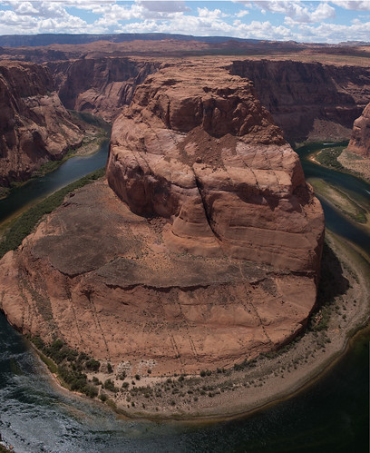
Outside of Moab, the Colorado River takes a more than 180 degree turn around the 1,000 fat pillar it has carved from the soft sandstone. This images was created by compositing three vertical shots, and I STILL could not fit it all in. The drop down to the river at my feet was wild exposure and with a strong wind blowing, I was not comfortable getting any closer to the edge.
Wednesday, June 9, 2010

Desert Flower Blooming

Here is one of Diane's favorites. All around was hot dry red dirt and sand, with a howling wind blowing. Behind this one rock, these delicate blossoms were flashing to us saying - look, look, LOOK!
Prickly Pear Bloom
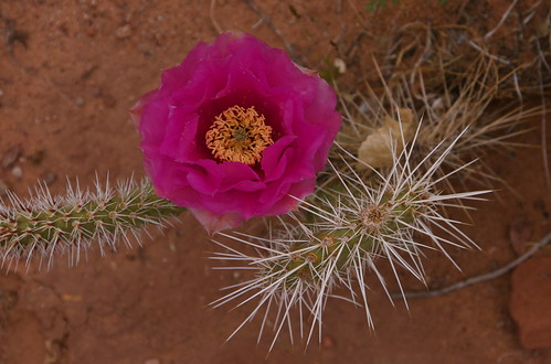
We hit the southwest desert with everything blooming. The juxtaposition of the delicate blooms with the self defensive other plant structures was fascinating.
Thursday, June 3, 2010
This Journey's End - posted from Winnemucca NV
We finish off the open wine in the cabinet by 4:00 pm, crack a new bottle, and play meditative native Indian flute music on the stereo while we tell each other stories of our fond and recent memories - reviewing photos and catching up on e-mail (our first internet connection for the computer for over a week)
Tomorrow we will reach Reno by lunch - a familiar stomping ground. Once we've taken care of a few shopping errands at Trader Joe's we'll head up to Donner Summit to catch up with Jim K. who is still writing us and telling of deep snows and impassable hiking trails. Too bad we did not bring skis on this lap.
( Here are some photos from the last week. A slide show is embedded. Click anywhere on the black border, and the slide controls will be exposed at the bottom of the frame...)
Once I get back, I'll prepare a selective group of these photos for sale as Greeting Cards, post cards, matted wall art or posters and if you are interested you'll be able to go to my Red Bubble site (link on left of page) to select and purchase items you like.
Wednesday, June 2, 2010
Windmills taping Salt Lake air - Antelope Island State Park
Evening hours award us with fine views of the antelope herd, many jack rabbits, a family of quail and an amazing light show by the setting sun(see photos posted above). After our evening photo shoot, we return to our campsite and find a very large bison grazing not 20 feet away in the dusk. He uses a large rack there to rub and itch - undoubtedly bothered at some level by the same midges we are as well as his winter coat, which appears to be coming off in sheets. We watch him until it is too dark to distinguish between the bison and the shadows, then turn our attention inward and prepare for bed.

Monday, May 31, 2010
Dead Horse Point State Park, UT
We have spent the past few days here in the high mesa country north of Moab. The landscape is dry and sparse, with each plant taking advantage of the recent late season snow melt to show it's colors and bloom. The trees are all pygmy sized, but these hearty desert survivors are no doubt old - some over a hundred years. We see dwarf pinion pine, juniper and in the shaded, well watered draws of canyon folds, relic Douglas fir - hold outs from a time when there was more water. The prickly pear are all in bloom as well as lupines, and some orange colored leggy flower we have not yet identified. The slick rock protrudes in rolls at the high points and is subverted by muddy sand in the low spots. Today while riding I am startled by a rattle snake moving across the trail.. Now, every stick I see gives me pause, and I slow down on the blind corners while riding. A few varieties of lizard dart back for cover as we peddle by, but some, seem to be more curious, and stay perched, doing push-ups on their sunny perches while we observe one another. Our riding improves and as gain confidence it's as if the bikes themselves are becoming more familiar with the type of terrain we encounter and we roll over sandstone drops, hop up onto small ledges, and let the full-suspension absorb the general unevenness of the single track slick rock and wash near the mesa's edge.
Yesterday we explored "Island in the sky" by foot, walking well over 10 miles along the mesa's rim. This part of Canyonlands National Park is aptly named because it is a high, rounded mesa surrounded on 360 degrees by canyon walls dropping down to both the Colorado and Green river gorges over 2,000 feet. The mesa is connected to the surrounding land mass by a single, 30 yard wide neck of land that has served to provide access to and control over these fertile lands as long they have been occupied by humans. In the early days, the Indians herded big horn sheep towards the neck, where they harvested what they needed before letting the others return to the mesa. Later, cattle men used the neck to collect open range grazers that had been at large and roaring freely for the feeding season. Now, there is a roadway across the neck, and tourists like us it to access the incredible views beyond. There is a hair raising dirt road here, that switchbacks down the canyon wall to the white rim elevation where it joins with the famous white rim trail (really a dirt road) that skirts the park and the canyon of the Colorado river at a fairly constant elevation for over 100 miles.
Hiking on the "island" I am reminded of the floating islands imagined in the movie"Avatar" where there is a self contained eco-system, floating suspended in the air. I practice walking meditation as we pass through this landscape, breathing in the dry and roasted desert air and letting it infuse me with calm and peace. I imagine myself floating over the surface, and somehow, my reptilian brain manages the logistics unconsciously of stepping up, over, around, on top of, and down the red rocks and sand. When I look out, above my immediate surroundings, the closest horizon is easily 20 miles away in the blue hazed snow covered La Sal mountains, and looking down from the crumbling mesa edge, as if on a mountaintop I see the dark brown, gray, red, and tan striations of the tortured and eroded mountainsides that have been shaped by the river's million year land shaping efforts and the sands of time carried by the strong local winds. Once away from the parking areas, it is quiet and peaceful, and very transformative as I mindfully pass through my surroundings. When sitting at the mesa's edge we soon begin to see the large bird community that call this special are home. The ravens seem to glide effortlessly by on the updrafts, with occasional flaps to adjust pitch and direction. When they pass close by, we can hear the wind on their wing tips as a deep whoosh. If they are flapping we can hear the whomp, whomp, whomp of the compressed pillow of air they force downwards with each stroke. The swallows and swifts on the other hand are moving at mach speed, required undoubtedly to catch the insects they subsist on. Their wings are swept back and their tails are sharp and forked, like a fighter jet and they literally seem to rip the air as they accelerate by, always turning, arcing, rolling, or diving - never seeming to fly straight and level. When they choose to come close to inspect us for hitchhiking bugs the sound we hear is more like a high pitched "zing" as they roll away just before impact. Perhaps our older ancestors attracted more of a colony of insects in their hair or clothes so the birds have learned to look at us for a take-out snack when we approached.
Saturday, May 29, 2010
Mill creek loop outside Moab.


Friday, May 28, 2010
Great bike shop in Moab
Lee Bridger helped us out with some bike parts and advise. Highly
recommended. Lee wrote a comprehensive guide to mountain biking around
Moab and has a great perspective. Being a transplant from SF we have
similar political views. If you are in Moab look Him up. He offers
guided bike rides and sells a US made line of mountain bikes.

Tuesday, May 25, 2010
Mesa Verde Petraglyphs

Monday, May 24, 2010
Saturday, May 22, 2010

Canyon de Chelly - Spider Rock Camping Ground
We meet Howard Smith, the Navajo owner of the campground and he introduces us to his nephew Benjamin who takes us on a five hour hiking tour down to White House ruin, then up canyon to Sliding House Ruin via Benjamin's family's land on the canyon bottom. Heard many stories of growing up in the Canyon, and changes he's seen since the mid 50's. Saw many petroglyphs (carved) and pictographs (painted) rock art on the canyon walls, and pottery shards 1,000's of year old - still holding their glaze and color. The wind continues to howl, but in the canyon most of the day we are protected from it's abuse. We see Benjamin's family goat herd, his two horses, and the land his family has cultivated continuously for generations(except for the period of the long walk and internment at Fort Sumner). Following our hike, we sight see to Spider Rock, a 1,000 free standing pillar at a bifurcation of the canyon. This pillar plays strongly in the Navajo spider woman story how weaving was brought to the people. We retreat back to the camping ground to escape the wind and the blowing sand and spend our evening "indoors" in the camper napping, reading, and reviewing photos.
I strongly recommend this campsite and this guide (Benjamin) for hiking, horse riding, jeep tours, and multi-day camping trips into the canyon. Make arrangements through:
Spider Rock Camping Ground
PO Box 3797
Chinle, AZ 86503
1-877-910-CAMP
info@spiderrockcampground.com
ww.spiderrockcampground.com
(Slideshow embedded below. Click on the black frame to expose the slide show controls, then press the play button at the bottom of the frame...)
May 22 - Canyon de Chelly
We leave Hovenweep National Monument this morning. The stunning stone towers of Little Ruin Canyon are astounding - guarding over the springs and narrow canyon access. The holes in the walls of the ruined towers are at many different angles and archeologists are not sure of they were viewing ports for spying intruders, for making astronomical observatories (to better anticipate the coming of the spring, summer, fall, and winter solstices, or to support some part of the interior architecture that has since collapsed.
This canyon sits within the larger Cajon Mesa, a sage strewn bit of high land over 5,000 feet above sea level and 500 square miles in bredth. The Mesa, in turn sits within the even larger Great Sage Plain that dominates the bulk of this part of the Navajo reservation. Over 700 years ago, this area had a thriving system of settlements all within a days walk of one another. But now, they are all deserted - except for the scattered Navajo family settlements up on the mesa tops where oil pumping, sheep, cattle, and horse ranching still occur in the open range land.
The wind had subsided briefly in the wee hours of the morning, but it has returned with some punch this morning. WE are hoping that below the rim of Canyon de Chelly we may find some relieve in a few hours.
We push southward through a driving sandstorm on weathered two-lane roads with rounded and crumbling shoulders across the reservation. No real "towns" per se here except for the occasional gas station at a cross roads.. People live primarily in scattered family groups, often multi-generational with one house structure per family, plus a shared hogan for ceremonial and healing purposes, a coral built from native materials and a scattering of abandoned locomotive technology. The road traverses open range land for horses, cows, and sheep. No one family "owns" the land they are using - the land is all owned by the Indian Corporation, but family groups have long standing territorial claims to the resources in one area or another and these are rarely challenged.
A strong win blows all day and kicks up a dust cloud that stretches from horizon to horizon. At times the roadway is completely obscured by the brown penetrating haze and we must slow to a crawl to continue forward progress. We fire up the emergency flashers and hope whomever is behind us is not so foolhardy as to pay any attention to the speed limit signs. Drifting sand begins to encroach on the roadway in places, seeping in from the shoulders and leaving residual wisps behind. The heavier gusts are not just felt by the sudden pressure on the side of the camper, but seen as well as a visual wave of sand races by - thicker and darker than the surrounding haze at 50 mph. The camper rocks and bucks, but ultimately keeps its feet well adhered to the roadway and we keep moving. At some point today the windshield cracks just below the windshield wipers under the withering disparate pressures of blazing heat, pumping air conditioning, and pounding pressure from the wind that at times must double our virtual velocity pressure. Yesterday a decorative plastic side panel 3' x 5' blew off as Diane was careening down a mountainside. I looked back and saw the part cart-wheeling backwards across the roadway before it came to a sliding halt in the middle of the road. We pulled over and recovered our severed payload imaging al the while where on earth we would stow it on board until we could determine what else to do. Now that side of the camper sports an ugly gash of black rubbery construction adhesive applied in sloppy bands where previously a sporty textured panel had been installed. We hop back inside, tossing the ungainly panel into the galley and slam the side door before more sand blows in, and keep moving.
At last we've reached Canyon de Chelly, the original stimulus for our entire journey. After watching the visitor center video (very informative), taking the south rim dirve and stopping a all the look-outs, and hiking down and back out again from the white house ruin, we have camped at a primitive site in the Spider Rock campground near the end of the south rim road. ($10 per night). Even tucked up tight along side of a sturdy spreading juniper tree on the windward side, our snug camper sings a variety of tunes depending on the wind strength. A fine patina of dust has settled on all the surfaces and underfoot and our skin and eyes feel gritty - like how you feel after a day at the beach. There is the general roar as gusts howl overhead and around the tree, and the hiss of wind of varying frequency as it passes over and around the galley vent - even though we have it snugged down to reduce dust intrusion at the moment.
The sky to windward is a brown haze but even now at 8:00 pm to leeward the sky is showing shades of blue - perhaps there is hope after all for tomorrow's excursions.
The campsite's office is a dirt floored covered porch attached to a ramshackle plywood structure that is the proprietor's house. A similarly unfinished structure sits adjacent and across the covered breezeway offering solar showers for $2.00. A marine style wind power generator is turning frantically in the wind, even though it's mast has fallen over and is tipped 45 degrees and leaning up against the house. A sign says $2.00 internet 6-9 pm and I see a computer on a small table in the corner of the room. We'll live without that for now.
A deeply tanned woman transplanted from Washington state in a sun-dress and flip-flops with matching ringed Navajo tattoos on each upper arm offers to help us as we wander about looking for the campground host. She gives us a brief orientation, tells us about a local Indian who will stop by in the morning and offer guide services to anyone interested. She apologizes for Howard, the campground's proprietor absence, and informs us he is preparing for a "sweat" just now and won't be out of the hogan for a few more hours. We retreat to our camp site behind the juniper tress and prepare a simple dinner.
We take shelter in the camper as if its raining outside to make a respite from the relentless wind and biting flying sand. The juniper sways with the gusts and the western sky turns bright yellow, then orange, then brown as the distant sun settles below the horizon.
Friday, May 21, 2010
Thursday, May 20, 2010
Bike Riding - Monument Valley, AZ Surealistic landscape and reasonable temperatures. Every direction is otherworldly . Had to change flat tire on camper today. Tomorrow in search of a garage to fix flat.

(Slide show embedded below. Click on picture frame to display slide controls..)
May 20 - Monument Valley
We depart our isolated campsite on a 7,000 foot ridge covered with ancient pinion pine, juniper, and Mormon tea in Navajo National Monument and head for Monument Valley. Somewhere along the way, probably while crossing some unanticipated cattle grate we damage a tire and begin loosing air.. but that's a story for later.
We arrive and are astounded. When we return from the visitor center, formulating a plan for the remainder of the day, we find a note on our windshield alerting us to a rear tire low on air. Sure enough, one of our four sturdy tires looks like its in trouble and we begin to problem solve our way out of this dilemma. Diane calls AAA and they agree to come help us - albiet in about 1 1/2 hours as they need to dispatch from Blanding, 90 miles away and across the Utah state line.
We use the time for lunch, a brief siesta, and to catch up on reading and soon enough a SUV pulls up along side and we begin to protest, holding the space for our expected yellow and blue rescue truck, but the young mane emerging from the driver seat has on a blue uniform and a name tag, and he asks, "you the guys who called?". He struggles for a bit to find a jack in the back of his cramped truck beefy enough to handle the task of hoisting the rear end of our camper off it's damaged tire - that being no small feat with semi-full tanks for fresh water, grey water, black water, and the mountain of food, clothes, and equipment we have packed on board. We debate the finer points of the jacking point, referencing the instructions in our trusty manual, and comparing that to his years of experience lifting vehicles for this very purpose. But ultimately the task was completed and we were again sitting on an inflated spare tire, the damaged original bolted to our back door in the spare's place for transport to a tire shop tomorrow 60 miles away. We move the camper to an amazing camping spot on a bluff overlooking the monument valley proper, unrack the bikes and spend the remainder of the afternoon on a 17 mile loop ride around this end of the valley.
Here is a quote from M. Scott Momaday, author of the Pulitzer prize winning novel "House made of Dawn" describing Monument Valley:
"The valley is vast. When you look out over itm it does not occur to you that there is an end to it. You see the monoliths that stand away in space, and you imagine that you have come upon eternity. They do not appear to exist in time. You think: I see that time comes to an end on THIS end of the rock, but on the other side, there is nothing but forever. I believe that only in the dine bizard, the Navajo language, which is endless, can this place be properly described, or even indicated in its true character. Just there is the center of an intricate geology, a whole and unique landscape which include Utah, Colorado, Arizona, and New Mexico. The most brilliant colors in the earth are ther, I believe, and the most beautiful and extraordinary land forms - and surely the coldest, clearest air, which is run through with pure light."
Wednesday, May 19, 2010


May 19 - Antelope Canyon
We start at a dirt lot in the high desert off highway 98 within spitting distance of the Navajo coal fired power plant, and after passing through a simple gate in the cattle fence, we walk 50 yards down a sandy trail and stop at a serpentine crack in the red brown sandstone earth. Looking up and down stream, the narrow opening with rounded edges heads off endlessly. I wonder, where is the canyon? Then, the indian guide simply motions downward and says "watch your step" and disappears down step by step into a crack no wider than his body - as if the earth just swallowed him up. When its my turn to descend, I just make out the narrow steel ladder that forms the entrance to Antelope Canyon.
To call it a canyon is misleading. It is a slot canyon to be specific. The bottom is formed by an off camber undulating sandy deck usually no wider than your two feet side by side - but sometimes narrower. From that narrow sandy wash, the walls rise up and swell outward in wavy patterns, never parallel, and rejoin again closer together overhead in a close embrace - as if in a delicate tango - teasing a touch, but never really connecting. The undulating and warm rose colored walls flow evenly from one bend to another, forming arches, tunnels, ridges, and bowls.
The bright sky overhead provides the soft light that has filtered down to where we stand, bouncing like a mad fuzzy pinball from one surface to another. As my watch hands rotate,at twice their normal speed, an occasional beam of direct hot white light flashes down and illuminates the floating sand particles that have been kicked up by our passage. They sparkle like diamonds - a temporal illusion, a translucent apparition, dissipating as gravity calls the wisp to earth, or a soft down slope breeze reorganizes everything as the sunbeam swings out of position.
The eyes, ears, skin, and brain are stimulated as an integrated organ while your consciousness tries to make sense of this magical place. Eyes scan around in any direction to gain a fundamental horizon and give up, left swirling like the sandstone layers. The harder and softer layers of stone have left signature lines that follow the wall's curve like topographic lines on a map. The ancient seabed gives up season by season of its story from wet years to dry years and the walls are painted with the pulverized remains of the eroded mountains upstream. The fingers touch canyon walls, often no more than shoulder length apart, first one side then the other as we tip toe down the narrow bottom of the canyon, performing some odd dance that only the river and winds of time could choreograph. Trying to use normal walking skills to navigate the terrain is useless so we resort to more of a crab-walk push-up, hop, skip, and slide maneuver to move around the sinuous path. The fine grit on the surface clings to our fingers as we first touch, then release the handholds.
It's quiet, except for a raven's nest of fledglings. This pair of imposing birds have chosen this section of the canyon for a nest. The twiggy perch is over our heads, but below the canyon rim above, affording protection from a predator coming from either direction. The chicks complain as the parent bird flaps once and lifts off their perch and seems to float effortlessly away into the light and blue and sky above.
In places the canyon widens, carved by a swirling eddy at the base of a now-dry falls, leaving an oddly symmetrical cylindrical chamber with more breathing room for us and a place to gather different types of reflected light. In one such chamber, a Navajo guide passes us walking downstream. He offers a simple greeting and then begins to sign a harmonious melody as soon as he rounds the next corner away from us. The tune fits right in, folding in and on itself and finding the harmonies we've so associated with native American music - a fluted tune that sounds as old as these rocks and one which throws us back in time 1,000 years and back again once it subsides. The singer and his music are swallowed by the canyon and both disappear in short order. Was he real? We never saw him again for the rest of our tour.