Thursday, May 31, 2012

Hammock Time

Hammock Time,

A cool breeze ruffles the aspen leaves  overhead and the babbling brook hisses and tumbles in the crowded willow grove just out of sight.  The tall grass reaches almost up to the level of the slowly swaying colorful hammock stretched between two younger aspens - giving it a special elasticity and bounce only possible with youth.  Birds chirp happily in the surrounding bushes and trees and a inquizatve hummingbird flitters over to investigate the bright bands of color of my supportive sling. I recline here, enjoying hammock time, that special combination of space, time and spirit, when my body, weary from a day of hiking, and my skin, warm from a day in the sun, and my mind open, and quiet, and accepting of this incredible gift all seem synchronized.  I see the bright sun reflecting on the paper white skin of the aspen trunks, with the telltale eyebrows above each branch as they diverge from the trunk  I see the bubbles flowing down the brook, created in one drop over glistening stones, swirled in the pool below then disolved in the stream only to reimerge as new bubbles, of the same  clan further downstream.  I see the blue, blue, blue sky overhead, but under careful scruntiny, I can see it paler at the horizon, then ever so slowly deepening to a royal full saturated blue directly overhead. And I know, this is the way it always is here, this peaceful harmony in a secluded mountain valley on the edge of the Utah eastern desert,at the edge of the Great Basin, that region of ancient seas  in southern Utah and Nevada, now defined by circumferantial uplift and erosion with or without my observations - and I want to be able to channel this peacefulness, and harmony, natural power and balance again, when I need it for strength.  I know this is special, and flitting, but for now, I am in the midst of good mojo, and calm and satisfaction. I am relishing in.... hammock time.


From 2012 Spring trip

Wednesday, May 30, 2012

Wheeler Peak, Great Basin National Park


5/30/2012

Camped at 10,000 feet just below and well in sight of Wheeler Peak.  This campsite is astounding - a forest service gem, with the trees stategically thinned so each terraced site on the upper loop (20, and 22 in particular) have unimpeded views of the summit and adjoining ramparts.  We are here early in the season, the aspen trees which surround our campsite have not even leafed out yet, and the only wildflowers are the small, ground hugging variety we saw up high n the scree fields.

There is a small bristlecone forest around this elevation on the slopes nearby, and there is a wonderful, well marked and easy to follow trail from the end of the road through  the bristlecones up to the Rock Glacier, directly below the summit cliffs.  Backtracking from the toe of the Rock Glacier, there is a looping trail, meandering through high alpine meadows and tangled pines to a series of alpine lakes, barely freed from their winter's embrace of snow and ice.  The whole Rock Glacier/Alpine Lakes loop, is under 6 miles and even with many photo stops along the way and a extended lunch break siesta high in the morrain, we were back to the car by 3:00 with a 10:00 am start.

In the parking lot yesterday we met a wandering couple Ric and Ami who live full time in their modest camper now after spending over 10 years living aboard a 40 foot catamaran and sailing up and down through the Carribean until they were forced ashore by the untimely fire that rendered their floating home inhabitable.  We immediately hit it off on a litany of similar interests and were introduced to the term PLU - "people like us". Ami is always on the look out for such acquaintances, and her enthusiasm for every topic was contagious.  We spent the day hiking, and taking photographs, and talking about adventures, and ended the day with new found friends. Hallelujah!

Today, the day breaks clear and warm, in the mid-50's and we are gearing up to hike from here to the summit of Wheeler peak - 13, 063, that's 3,000 feet up from here.  I have no delusions of making it to the summit, but will enjoy the climb as far as we get.

The well graded trail winds up through the scree, and leaves the treeline around 9,500 feet.  The views east grow as we climb up the shoulder of this massive pile of apparently loose  and broken rock   Periodically we pass low row wall shelters someone has constructed  to provide a respite from the howling winds which must scour this desolate high ridge with some regularity.  Today, we have it easy, with a mild but chilly breeze, that keeps us layered up even though we are working at a rigorous pace.  By 11:30, we have reached 12,000 high on a shoulder and can see to the west now, and the vast field of large and powerful windmills that have sprouted outside the town of Ely.  We are able to see almost 360 degrees from this ridge and all around and far below we see the vast sandy plains of western Utah and eastern Nevada.  Diane, Ric, and Ami opt to relax behind a low stone shelter and have lunch while I push on to the summit, still 1,000 feet above us.  Now I can feel the altitude but I step carefully and steadily as the trail becomes steeper, and on more uneven terrain.  Thin rivulets of snow still reside at this elevation and I cross snow fields on a few occasions opting for the easier snow veins for upward motion as opposed to the loose rock. alternative.  Near the summit, I must traverse a steep snow slope with excessive exposure on the east side, dropping precipitously   to the lakes we were hiking at yesterday.  I am kicking steps carefully, not stopping to consider consequences, but I am confident,and the snow is stable and just the right consistency to support my endeavor.  Heart pounding, but just enough so I can keep moving - step, step, step and then all at once, there is no more up. All aroundI see blue and puffy clouds.  I stand up straight  expecting to be buffeted by a wind, but it is dead calm.  All the way up the ridge there had been a strong wind circulating around every aspect of the upper slopes and now, just on top it is as if I am in the eye of a tornado. No wind at all.  Amazing vistas, 60-100 miles in every direction. I peer over the edge and can just make out the colorful specs that must surely be the jackets of my compatriots hunkered down in the rocks far, far below.  In an instant it seems I look down to my watch and I have been on the summit 30 minutes.  How can that be - I just got here? Not wanting to worry the rest of the team, I started down, happily leaping from one rock to the next, enjoying the steady pull of gravity, instead of its relentless tug from the way up.  The path is uneven, and sharp, but my boot soles stick well and I am happy.  Not happy to be off the summit, but happy to have reached it, and happy to be happy with all systems operational. Hurray!

I rejoin the others in 30 minutes after jogging down the final snow field and we slowly meander our way back down the remaining 2,000 feet to the car making stops often to wonder at the landscape and our little place in it.

This evening while eating dinner we are surprised by three turkeys which wander into our camp looking for grubs and whatever else is their usual  dinner fare.  They see us and alter course slightly, then ramble back off into the brush.  We see them again the next day, regaining a few more members of their party.


If you go:  Although there is water at these campsites, it comes with a warning about high aluminum content, and warns away small children and pregnant women from consuming it.  We too will stay away and use the water we already have on board.

The hike to Wheeler peak is 3,000 feet up and 3,000 feet down from the trailhead, but is rarely steep and well worth the effort. Set a good turnaround time and follow your plan. Be prepared for rapid changes in weather.

The rangers provided a great astronomy program at night - this park is one of the darkest places in the continental US and offers great star gazing. They set up a big telescope and showed us astounding views of the moon, and Saturn - it really does have rings and we saw two of the larger moons as well.

There is a large marmot colony living along the Baker Campground road.  Look for the marnot crossing signs and then pull out and walk down the road to the rocky fields on the south side of the road - be patient and you may get a good long view of a family group.

Great cave tours of Liehman caves - plan on the 9:00 am tour which is the longest, and wear warm clothes no matter how hot it is outside.  The inside of the caves is around 50 degrees.


From 2012 Spring trip

Monday, May 28, 2012

Tower Arch, Arches National Park


5/27/2012
Tower Arch, Arches National Park
Outside Moab, 18  miles up the paved park road, and 8 bumpy miles on a dirt road from there took us to the trail head for the Tower Arch hike.  We have crossed a wide sage covered plain with several dry washes to come to a geologic region of upthrust and then eroded needles, fins, and resulting arches.  This trail is more rugged than the usual park fare and its location at the end of a long dirt road also help to cut down on it's visitation.  For today, and for now, we have the trail to ourselves except for one other family who passes us easily as I stop often to take photos.

The wind has receded, and the clouds have returned with the arrival of a cold front, so we have a few layers on as we hike. This is certainly a pleasant change from the scorching heat and hammering wind that have distracted us for the last few days.  The wind itself at these speeds was a real issue to contend with.  Besides the blowing sand which blasted our exposed skin like a thousand needles, and the grit which formed in our teeth and filled our ears, the force itself kept throwing off balance.  That along with the noise, and howling, and whistling which made normal conversation virtually impossible, unsettled our whole spirit.  No doubt, it was exiting, and relevant in a place like this which has been literally formed by wind events like this, but normal equilibrium was disturbed. Our sense of peace, balance, and timing were all effected.  It was a true luxury to retreat to the shelter of the camper after each foray into the elements and feel the uneven rocking of the vehicle on its springs, like a boat in heavy swells, hear the whistling of the wind as it sought every small crack in the seals to join us in the cabin.  We heave huge sighs of relieve, and calm our breathing to its own normal pace instead of that insisted upon by the gale blowing past our noses and mouth when outside.

But today, the wind is calm and the plants seem happy to just sit in the sand like most days instead of yesterday, when they were being pulled by their roots and tossed across the vast landscape.  Birds came out and perched on the branches and chirped as we passed, and large ravens soared on the updrafts looking for a meal.

The trail, after it's initial 200 foot climb over an escarpment, flattens out to a pleasant rolling ramble through the sage and cactus covered plain between towering rock abutments with amazing eroded shapes. After only 1 1/2 miles, the trail passes through a short slot in the rocks and upon climbing out of the slot, there is the large and elegant "tower" arch, supervised by a towering columns of red stone with a rounded boulder, as if a spaceship has landed on a pedestal. 
While leaving the park afterwards, we stopped at balanced rock, and Park blvd., both destinations well worthwhile, although both a bit crowded on this memorial day weekend. 
From 2012 Spring trip

Saturday, May 26, 2012

Retreat from U-Turn, Arches Nationl Park

Attempted the U-Turn canyoneering route in Arches NP today, but we were forced to retreat before completing it by 60 mph gusts in the saddled which prevented us from proceeding safely.

From 2012 Spring trip
Diane crawling on her stomach to keep from being blown off the high wide pass we tried to cross to rach the normal decent portion of this tour. To each side was a sizable drop, and the wind kept literally knocking us over.

From 2012 Spring trip
Down climbing on a short rope belay. We retreat down the way we came up. No rappelling today....
From 2012 Spring trip
Short hike back to the car, where a heavy women was blown off her feet on the sidewalk in front of our eyes and fractured her ankle. I did an initial assessment, organized the family to make shade and stabilze the injury and then 911 was called. We retreated down the mountain to town to listen to music t the festival and rest on the cool grass in the shade...then limbs started falling out of trees, and craft peoples booths started blowing down. We retreated again to a gelato shop to post this release.

Camel's Toe, Moab, Ut

From 2012 Spring trip
5/25/2012 - Camel's Toe, Moab, UT

The blazing sun has finally settled  behind the 200 foot red rock cliff adjacent to our camp along the Colorado River off route 279, 5 miles outside of Moab.  There are many BLM primitive, and small campgrounds here, nestled between the river and the cliff with 5-10 sites in each.  We've come here to get out of the hubbub of town, and to capitalize on the high winds over the cool, wide river to cool us while we shelter from the sun under a copse of cottonwood trees in the late afternoon hours. 

 Today was another high wind advisory from the National Weather service, with gusts up to 50 mph and there is a pale brown twang to the sky from all the entrained desert sand pushing out the normal deep blue we have become accustomed to in these parts. We had left our campsite early this morning to use the cool morning hours for the climbing segment of our canyoneering day on the Camel's Toe loop.  It turns out, there really are not printed books describing the canyoneering routes in the Moab area.  Most routes are passed either by word of mouth in the local community, or via some subscription only blog sites on the internet.  We opted for the blog subscription, and evaluated a series of options using the iPad last night while sitting in camp, and selected a fairly "straight forward" tour from the collection of rather extended and more technical choices.

With no clearly marked trail, only  a starting point, and rather grand and vague terrain descriptions  are available to help guide us through the foreign terrain.  We parked at the Corona Arch trailhead, 10 miles from Moab, and chatted up the guys in the car next to us in the lot, full of climbers also getting ready for an early tour.  We were kind of hoping they were heading the same way as us to help ease us into this new world of self-guided canyoneering, but they had other objectives in mind (rigging a gigantic rope swing on the nearby 100 foot high  Corona Arch) so we traded some gear notes and headed off in different directions.    
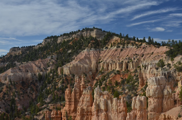
Soon though, after an auspicious start passing by some ancient cliff petroglyphs, we learn to read this scorched and smooth terrain much like high snow covered alpine slopes we more often traverse and make our way through  the rock choked drainages of this incredible canyon.  Let me set the stage, rising above us easily 1,000 feet on each side of the main canyon are polished sandstone cliffs. They have broken and eroded into fantastical shapes by wind and water and have been polished and varnished by eons of exposure.  In some areas there are high tallus slopes where entire towers have crumbled into a heap.  Other places there are smooth terraces and ramps leading diagonally along the cliff bases.  All over there are cross gorges, and drainages confusing the routes. It is spectacular and glorious, and a bit intimidating.    The internet guide offers advice, like: "follow the terraces to the right of the dry falls working your way up canyon avoiding the bigger drops".  We are concerned about the specific BEST alternative, but really, it boils down to picking terrain that works for your specific party, being willing to backtrack if cliffed out, and keeping the bigger objectives in mind while staying oriented in the confusing jumble of rock fall, slick rock, and terraces.

We make a few wrong turns after relying on GPS coordinates which must have been based on a different reference grid, and ultimately tuck the useless device away and work the canyon the best we can.  Occasionally there are rock carins left by previous travelers, and   sometimes we follow a worn path in the sand, but we continue to find our own way, feeling some relieve when it intersects with the other clues, but not driven to stay on some specific path dictated by others.  This is a complicated way to travel, and offers tremendous intellectual stimulation  coupled with the physical exertion of moving through the broken terrain being careful not to step on any undisturbed cryptobiotic soils in the process or kick off loose rocks.

The sun is rising along with the temperature, and we are careful to keep our pace sustainable, stopping to rest in the shade on a regular basis.  We bypass one side canyon and continue upwards, but the canyon walls rise as well, and at times it is hard to figure if we are winded going flat, or actually hiking uphill.  As we crest one dry falls, we spy from the side and above for the first time (just as the guide advised us), the crux of this particular adventure, the hanging pool named the "Camel's Toe" from which we will later need to rappel right at the spill over.   The route continues to trace the rise of the deepening canyon, but we can tell there is a series of ramps now leading down to the actual canyon bottom, a clue that we have climbed high enough and it is time to turn around and begin the downhill journey via the sinuous and ever narrowing water scoured riverbed.   It begins to be more joyous as we skip from one large rock to another moving downhill now returning to water reserves in the car.  In places the riverbed is scoured smooth, with linked sinkholes reflecting the springtime and storm cycles when a raging torrent pushes down this same channel. But, for now, every thing is dry except for a few lingering sinkholes and pools beneath the larger drops where the shaded grottos bring us vast relieve from the otherwise exposed conditions. Then, at all at once, the channel shrinks to a narrow gorge with a polished slickrock floor, swerving first one way then the next in an ever narrowing canyon with walls 20 feet high, then all at once before  us lays the Camel's Toe, a cool and sand bottomed pool at the end of this short slot canyon section, with water reaching from one side wall to the other. Beyond the pool, a  drop-off of indeterminate height.  

 Giddy with excitement, I strip naked to preserve my clothing and footwear, don flip flops and wade into the thigh deep,  clear water.  Following the sandbar towards the center I stay away from the undercut edges of indeterminate depth and reach the sun bleached pour over highly satisfied. I had been so concerned after experiencing the cold water in Zion Park, that this challenge may prove too daunting for my thin frame and stop us in our tracks. Whoops and high fives  all around. As expected, and foretold by the internet guide, there were two solid looking bolts secure in the rock near the edge of the pour over. I gave them each a solid tug, and reported back to Diane that she should follow and that the route was a go! Once dry and redressed after the pool, we put on our harnesses, and double checked knots and gear.  We readied the ropes together, double checking each other and gave the coil of rope a toss, listening carefully for the telltale thump as it hit the ground far below.  Tied off to an anchor, I leaned over the edge to confirm our doubled line had indeed hit bottom, Diane tied on first, and struggled over the sharply undercut lip,.  This deeply undercut falls turned the rappel into a free rappel,  no wall to step down after the first tentative and difficult steps over the edge.   Once over the edge, I could no longer see Diane, so she chatted non-stop to herself so I could tell she was still moving and okay on her way done.  Once she was clear at the bottom, I looked around, double-triple checked the fittings and followed her down.  As she had reported the first five steps were very challenging, but then I was in the shade of the drop-off, and casually looking at the baby's breath ferns growing tenaciously from the seeps behind the falls.

This route is really no big deal, but for us, a big achievement, rekindling old rope skills learned and then abandoned years ago for more tame endeavors.   Once we were both down, I tugged carefully and as planned on one end of the doubled rope and hauled the 60 foot free end back up to the top.  As it slipped unwitnessed though the steel ring we left up top, it came tumbling back down to join us in a heap.  We coiled the lines and stowed our tech gear,and followed the broken and sandy  drainage back out to the highway, using a long and very large culvert to cross under the train track spur crossing the canyon mouth and returning to the highway. A four hour projected tour turned into a five hour tour due to our initial missteps and casual pace, but all in all a great adventure.

Once at the highway, we chugged our remaining water supplies and trudged back to the car in the shimmering heat, anxious to return to camp and shaded reclining chairs for a well deserved siesta.

 If you go: Carry two liters of water a piece, pace yourself, and drink it all in hot weather - don't get behind  Bring a first aid kit - plan on a few scrapes and cuts along the way. Do your route research in advance:  http://climb-utah.com has a wide variety of options described - be prepared to pay for the tour details once you have narrowed down your selections Make sure you have the right gear for the tour - and some extra  Bring a compass.... and use it - often.  It is easy to get turned around in unfamiliar terrain Remember as the National Park Service likes to spout: "Your Safety is Your Responsibility"

Thursday, May 24, 2012

Chesler Park, Cayonlands

5/24/2012 Elephant Hill Trailhead to Chesler  Park,The Needles, Canyonlands NP,  The sun rises through  striated cirus clouds and with the dust in the air long fingers of brightness reach down from the cloud layer above to touch the desert floor outside the camper.  A cottontail rabbit awaits our viewing as we pull the shade up for breakfast.  Low angle sun reaches under the clouds to illuminate the escarpment 20 miles away which forms the supports for Island in the Sky.  We get up early to take advantage of the cool morning temperatures for an extended hike and drive back into the park and to the Elephant Hill lTrailhead at the end of a three mile dirt road.  From here we start hiking and are immediately absorbed by the fantastical surroundings.  Muffin topped hoodoos, with thick necks sit squatly all about, as the "needle" formations from which this section of the park takes its names, sprout up on each side of the trail and draw us ever upwards and into this unimaginable landscape. The trail is loosely visible as it crosses sandy sections and is marked by piled stone cairns as it crosses over the slick rock and jumbled dry washes. With about 1.5 hours effort, we reach a high divide offering views deep into the parks inner sanctum, and the wide open grassy plain between perimeter needles of Chesler Park.
From 2012 Spring trip
Yellowand Green Morman Tea Plant...
From 2012 Spring trip
Can you find Diane in this photo?
From 2012 Spring trip

Tuesday, May 22, 2012

Capital Reef National Park

05/22/2012 Capital Reef National Park Get here early in the day, as the limited camp spaces fill up quickly.... The drive from Bryce to Capital Reef is astounding, with impressive views to the south of the Grand Staircase/Escalante National Monument.  In the valley bottoms where water is available lush horse farms span from one sand stone wall to another. Then the road begins to climb and climb and the naked stone landscape is supplanted with grass covered hills with massive groves of towering aspen trees.  The road climbs to a high ridge ultimately topping out at 9,800 feet. The air is cool, and the scenery looks more like the Rockies, then the desert southwest until you glance southward and see far below the variegated, and jaggedly carved red and orange mesas of the lower elevations.  We can still see some isolated snow fields up high above the road and pass several Dixie National Forest campgrounds before the road once again dives down  a 10% grade into the heat and stark landscape of the Capital Reef.  We sit out the heat of the afternoon parked in the shade of a cottonwood grove, and plan to move out around dinner time on the hunt for photographs along the scenic drive in the capital reef park.
From 2012 Spring trip

Bryce Canyon National Park

5/21/2012 Bryce Canyon - Sunset Campground - The burning sun is low in the sky now, and we sit shaded by the awning, and looking out at the manzanita and Ponderosa Pine forest which surrounds us.  At 8,300 feet, the air is clear, and the breeze is cool, but we are clearly still below tree line.  We have spent the afternoon hiking the Bryce Canyon Rim trail, from north towards south - the preferred direction since it is generally downhill.  The park runs a free shuttle bus which allowed us to leave our car happily waiting for us at the campsite while we took advantage of this shuttled hike.  Our reward, an ice cream treat once we reached the camp store, at Sunrise point. Don't count on much here besides cold beverages, the usual park trinkets, and a good selection of ice cream bars.  From the Rim you can see south all the way to Escalante - Grand Staircase National Park, and the Kap Ridge, set aside by the Clinton Administration, to the chagrin of local ranchers and miners.  There is still debate about the issue at the local watering holes.   The vista over the Bryce amphitheater with it's thousands of fanciful HooDoos standing at attention  - giving witness to the astonishing splendor of this lightening savaged high Colorado Plateau, so aged now by erosion is truly astonishing.  There is some speculation, that with global warming, and a reduction in the freeze/thaw cycles leading to increased precipitation as rain, these hoodoos will begin to be more rapidly eroded as the capstone layers dissolve more quickly than in any recent geological period.  But, for now, we imagine dwarfs and elfs, and apostles, and cathedrals, and all manner of other creatures, all standing side by side with the mighty red layered  columns.
From 2012 Spring trip

Zion Park - If you go......

Zion, notes  if you go: Zion flute festival Www.zionflutefestival.com May 17,18,19 2012 Springdale, Utah Zion Adventure Company - Outfitters and guides, equipment, shuttles and ideas Zionadventures.com Walker Gallery Springdale- amazing photographs, like a museum Whiptale Cafe, Springdale  Great casual tex-mex fusion food Really tasty Zion Outdoors Center -  bike rentals , road, and mountain. Take free shuttle up to end of park road and ride down road for fear photo opportunities.   drive to Kolab Canyon- breathtaking Hikes: Angels Landing - lots of climbing - breathtaking views Zion Narrows - canyon stream hike - get the right gear Bike ride DOWN the length at all turnouts for photos Emerald Pools to the Grotto

Sunday, May 20, 2012

Eclipse Watchers in Kolob Canyon

From 2012 Spring trip

Virgin River Narrows - Zion National Park

5/19/2012 Virgin River Narrows - Zion National Park We slam the sliding door shut with a thump and head off early in the 50 degree air.  The sun is low in the sky and its direct rays do not reach us here on the valley floor.  It seems odd to be dressed so rigorously, when many around us on the shuttle bus ride are dressed so casually in flip flops and floppy hats, womem in halter tops and babies in arms.  We are dressed in full-on dry pants - sealed soft rubber cuffs clinging tightly to our lower shins.  Thick neoprene booties cover our feet, and they in turn are sheathed in the latest 5.10 rubber soled canyoneering boots protecting our feet we hope from the torment that lies ahead. Under the dry pants are thick pile pants.  Our upper halvss are a bit less  protected, with two laters of quck dry fabric.  In our hands are stout wooden staffs, 5 feet long. Hopefully Diane will not be beating me with one of these by the end of the day. We get off the shuttle bus at it's last stop, at the mouth of the canyon at  Sinawava, and begin our walk into the ever narrowing slot canyon of the Virgin River.  We are carrying heavy staffs to help balance our weight when crossing the current, but for the first mile we stolll easily along the river's edge - growing more anxious by the step, what might lie ahead.  Soon enough, the trail terminates at the river's edge, and there is nothing but sheer sandstone cliffs closing in on each side of the river.  We tentatively step into the 50 degree water in the shallows and discover ......comfort.  The water pressure presses in like a firm embrace as the shallows deepen to thigh deep, and except for some trickles of water into our by now very hot feet, no water seeps in at my ankles or legs.  Nothing at all like a wet suit. Hurray!  We lean heavily on the staff, stepping carefully on the invisible rounded river stones below the surface.  Unlike wwarmer water streams I am more familiar with, there is little or no moss on the stones and the amazing shoes offer unexpected stability. Looking ahead and reading the river - backwards from usual, we look for the shalllow areas, where the flow may be a bit diminished.  The light is playing brightly 500 feet overhead on the canyons top, but deep here by the river, we get just reflected light after t has bounced from side to side a million times before reaching us and boucing off the translucent green pools that form in the river's eddies and quiet spots. We wind around large corners, marvel at the river's rounded undercut curves, and are astounded at each bend in the river with the sceanary which is unfolding.  In some sections we can get out of the water and hike on the sandy banks, but mostly we trudge right up the stream, or at it's very edge.  The water depth varies from ankle to waist, and the flow rate varies from almost calm to very strong, but no one in our party falls and we work our way up to "Wall Street", the fabled upper reaches of the lower canyon. When , after  lunch break, another 20 minutes of hiking brings us to the most remarkable site.  The river here stretchs wall to wall, waist deep, and the walls rise vertically at least 700 feet overhead.  Here, the Navajo Sandstone walls are covered with a deep desert varnish, but the sun is almost directly overhead and with almost no reflection on the walls plunges directly into the water illuminating it as if from below.  We want to continue up stream, and to explore more, but our water supplies are dwindling along with our food, and the way home is no easier than the way here. We snap a few pictures and follow the water back home.
From 2012 Spring trip
Eats: Check out the Whiptail Cafe, Springdale - amazing fusion tex-mex - fresh food, casual outdoor dining, fatastically friendly service. Don't let the converted gas station building diswade you. Go for the food! Outfitters: Checkout Zion Adventure Company - great davice - super high quality equipment - don't let anyone tell you otherwise - you need a dry suit and special shoes to hike all day long in 50 degree moving water! Bring or rent a big staff. Standard hiking poles will most likely be crushed